File:North Complex smoke in San Francisco - Financial District.jpg

Size of this preview: 800 × 533 pixels. Other resolutions: 320 × 213 pixels | 640 × 426 pixels | 1,024 × 682 pixels | 1,280 × 853 pixels | 2,560 × 1,705 pixels | 5,464 × 3,640 pixels.
Original file (5,464 × 3,640 pixels, file size: 19.16 MB, MIME type: image/jpeg)
Captions
Add a one-line explanation of what this file represents
Captions
SummaryEdit
| Description |
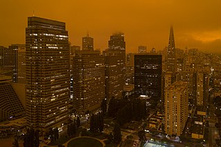
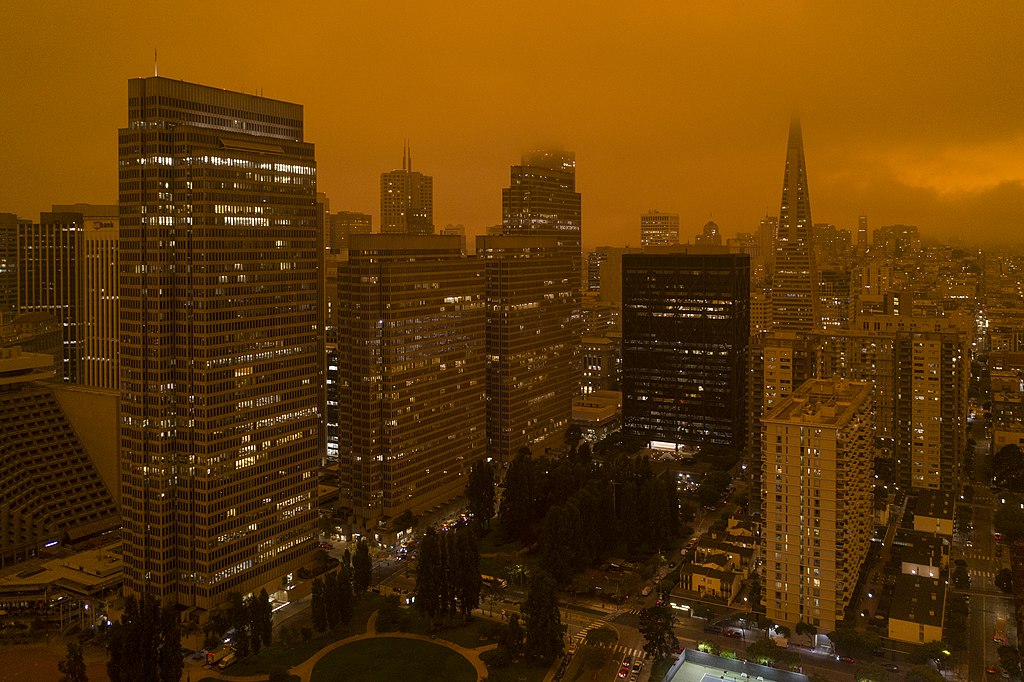
English: Smoke from the North Complex fire settles over San Francisco, turning the daytime sky a dark orange. |
| Date | 9 September 2020, 12:07:19 |
| Source | https://www.flickr.com/photos/cmichel67/50323747038/ |
| Author | Christopher Michel |
| Camera location | | View this and other nearby images on: OpenStreetMap |
|---|
LicensingEdit
| This file is licensed under the Creative Commons Attribution 2.0 Generic license. | ||
|
| This image was originally posted to Flickr by Christopher.Michel at https://flickr.com/photos/50979393@N00/50323747038. It was reviewed on 10 September 2020 by FlickreviewR 2 and was confirmed to be licensed under the terms of the cc-by-2.0. |
File history
Click on a date/time to view the file as it appeared at that time.
| Date/Time | Thumbnail | Dimensions | User | Comment | |
|---|---|---|---|---|---|
| current | 09:10, 10 September 2020 | | 5,464 × 3,640 (19.16 MB) | Mxn (talk | contribs) | Uploaded a work by Christopher Michel from https://www.flickr.com/photos/cmichel67/50323747038/ with UploadWizard |
You cannot overwrite this file.
File usage on Commons
The following page uses this file:
File usage on other wikis
The following other wikis use this file:
- Usage on en.wikipedia.org
- Usage on ru.wikinews.org
- Usage on www.wikidata.org
Metadata
Structured data
coordinates of the point of view<\/a>"}},"text\/plain":{"en":{"":"coordinates of the point of view"}}},"{\"value\":{\"latitude\":37.79759,\"longitude\":-122.394414,\"altitude\":null,\"precision\":1.0e-6,\"globe\":\"http:\\\/\\\/www.wikidata.org\\\/entity\\\/Q2\"},\"type\":\"globecoordinate\"}":{"text\/html":{"en":{"P1259":"37\u00b047'51.324"N, 122\u00b023'39.890"W"}},"text\/plain":{"en":{"P1259":"37\u00b047'51.324\"N, 122\u00b023'39.890\"W"}}}}" class="wbmi-entityview-statementsGroup wbmi-entityview-statementsGroup-P1259 oo-ui-layout oo-ui-panelLayout oo-ui-panelLayout-framed">